There can be no doubt anymore that extreme weather events are becoming more frequent in the 30-year hurricane cycle and more devastating for those involved. The sad truth is that we don’t have to look too far for the evidence, it is reported on the nightly news.
Recent scenes in Houston, TX, following the destruction of Hurricane Harvey, highlight the impact of major storms on large cities and populations. Further, flood waters continue to rage across Asia, with hundreds of lives lost and displaced.
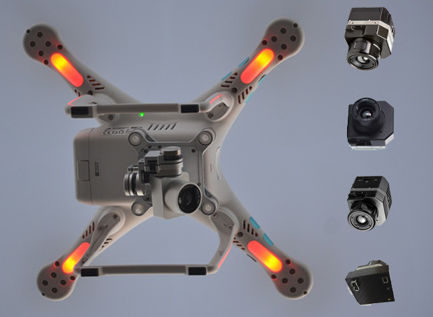
At the time of writing, Hurricane Irma beats a path across the Caribbean, and Florida residents try to plan for evacuation. This sharp increase shows that preparation is very important, but also the search and rescue efforts need to be updated. Rescuers now can use new state of the art equipment like the top-rated FLIR TG165 thermal imager
There is little that will impede the impact of these situations. We can’t guide a hurricane out to sea, and category five storms are too strong for many cities. Current forecasts for Hurricane Irma show that it is even difficult to predict precisely where these storms will hit, and with what force. However, we can change the way that we respond and protect the lives of those affected.
One of the best tools is to provide trained, effective search and rescue teams to look for those left behind. We should equip all search and rescue teams with aerial thermal imaging equipment to make the job a lot easier.
The use of thermal images and thermal cameras in search and rescue operations are nothing new. There are many coast guard agencies and other rescue services across the world that use thermal images on a small scale to locate missing persons. This ranges from those lost on mountains to those out at sea. At sea, a small body of the dark water can be difficult to spot by sight alone.
A thermal image picks up the heat signature as a bright signal in the cold water and allows rescuers to hone in on the subject. This is the basic principle for all thermal image related search and rescue. Timing is everything in these situations as there is a risk of drowning in the water and hypothermia in the wilderness.
This principle of finding bodies and survivors in a mass of water translates to the work of rescue teams dealing with major floods, such as those seen in the aftermath of Hurricane Harvey and Hurricane Sandy. This may not be an open ocean, but there are large stretches of flood water and submerged suburbs where every second counts to save a person. The sooner that rescuers spot these heat signatures, the better the chances of a successful rescue attempt.
Why are aerial thermal cameras so helpful for search and rescue teams in storm-damaged areas?
There are two major benefits to this approach. First of all, there is that ease of visibility. The sooner teams spot and locate someone in flood, the sooner a rescue team can get to them. A team scouting the area by helicopter or a remote-controlled unmanned aircraft can cover more ground for a clearer, bird’s-eye view of the people that are in the vicinity. They can then inform those on the ground that may not have a good view, but are then able to go into hard to reach places and retrieve the victim. This can save valuable time. It could take hours for a team on the water to manually search a neighborhood.
The second benefit is the increased safety for the rescue teams on the ground. It is difficult, dangerous work to head out to floodwater and debris, especially of poor visibility. Teams can put themselves at great risk with long, manual searches of an area in the hope of finding victims.
Many responsible teams will wait until the worst of the storm is over. There is still the risk of wind and rain, of debris in the water and areas of unknown depth. This method means that they can stay safe until they are sure of clear mission and clear path. They have the guidance of the team in the sky and don’t have to waste precious time or energy.
Why should search and rescue teams favor drones when working with these thermal cameras and imaging?
This idea of safety in search and rescue goes further when we bring drones into the equation. It is one thing to have a search and rescue helicopter scouting the area. These aircraft can offer a comforting presence to those trapped on the ground and provide a clear link between rescuers and victims. They also have the capacity and equipment to help those in need. However, it may be best to call the helicopters in only when and where we need them most.
There is no doubt that any high-grade thermal cameras on board provide clear images that the team can interpret in the air. They can relay that information to the teams on the ground. However, helicopters can struggle to fly in certain conditions, they need to refuel after a period, and there are health and safety concerns when placing pilot and other rescuers in danger.
Drones provide a different approach. They can fly into hard to reach places, due to their small size and maneuverability, which means they may be better able to locate some victims in hard to reach places. The best drones can also carry some of those top-of-the-line thermal cameras on board and relay the images straight to rescuers via a First Person View system.
Others favor drones simply for their speed and low cost. Teams can deploy these unmanned aircraft in a matter of minutes, with little prep time. It is also an estimate that they are
400 times cheaper to run than a helicopter. This cost is vital for poorer areas that may not have the funds and support for major operations. This is especially true if coastal regions need to factor more storm protection and rescue into their annual budget from now on.
The potential and benefits of drones in search and rescue are clear from recent events.
The 2017 InterDrone conference in Las Vegas saw a presentation from DJI Director of Education, Romeo Durscher. DJI, a leading drone manufacturer, had conducted a joint research initiative with the European Emergency Number Association.
One particularly interesting development came from Ireland’s Donegal Mountain Search and Rescue. They noted that the drones help to reduce rescue times on their missions significantly. A typical five-person rescue team took an average of two hours to find a victim in one square kilometer. The drone covered the area and found the victim in just 20 minutes. This could be the difference between life or death.
In fact, there are also positive stories of drone-based search and rescue operations within Texas. A recent example came from a search and rescue operation following heavy flooding in the state. The Joshua Fire Department received help in their search from a DJI’s Inspire one drone. The aim was to spot a missing truck that the team had already been attempting to locate for an hour. The drone spotted it in 45 seconds. Then there are reports from Hurricane Harvey operations. Their drones were able to spot structural damage where a roof was caving in with workers below.
Of course, it is not just the victims of storms, floods, and hurricanes that can benefit from this sort of equipment. The potential of these cameras and thermal images goes much further. Another important benefit here is the ability to locate people trapped within the devastation that comes with heavy rain in rural areas, but also in earthquake relief.
Disaster relief agencies and search and rescue teams always need to look beyond the event to the damage it causes. This means the rubble of collapsed buildings and the landslides from heavy rain and burst river banks. A drone can reach up high in these impassible areas to search for survivors.
The next step is to use drones equipped with the best thermal imaging cameras for the best of both worlds.
Drones are a must in these situations because they provide that quick, effective access to a situation where others may struggle. However, all of these stories so far talk about basic imaging with a typical aerial camera.
There are clear benefits to this approach, but a thermal camera could go a lot further. These cameras would combine the accessibility of drone photography with the heat-seeking images of thermal tech. The result would be a clearer image of survivors and bodies in these flood-hit areas, clearer images of a situation in low light and another perspective on the situation. The response time between take-off and locating victims could decrease again.
(Source: Digital Trends)
FLIR cameras lead the way for thermal images with drone technology.
Many in the search and rescue industry swear by FLIR cameras as the best possible approach for clear imaging in vast areas of water. There are different examples, but one of the most interesting comes from Norway. Here Norwegian search and rescue boats and other ships use FLIR thermal cameras for greater visibility of people, ice and other hazards in the water.
They say it is much easier to navigate around ice sheets and to spot kayakers or people in distress. They particularly like the FLIR Voyager as it offers two thermal imaging cameras and a low light color camera. This combination means that users achieve the best visibility of the water and its hazards 24 hours a day.
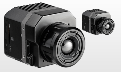
The range of FLIR cameras is vast and continually adapts to meet the needs of those in these sorts of industries. In addition to improving the optical capabilities and image processing, they also work on the hardware for improved compatibility. This means a series of new thermal cameras that are ideal for drones. These tiny, lightweight gadgets mount to the drone with ease, without compromising the flight or balance of the craft. They retain many of the same high-end technological features needed for clear, precise imaging in search and rescue operations.
There are many lessons to learn from Hurricane Harvey, Hurricane Irma and the impact on Houston in particular.
Many people will come away from these disasters and focus on what we could have done to prevent loss of life, or to lessen the scale of the damage. There will always be talk about the missed opportunities for evacuation and preparation on the ground.
Florida has some warning for Hurricane Irma, but there will still be those that cannot get away. Others talk about the political reaction to the scene and the media coverage. We can’t stop these hurricanes and storms from breaking when we know they are on their way. We can improve our ability to deal with the damage and find those that will inevitably find themselves caught up in the disaster.
This leads to one final benefit of using thermal cameras and imaging in these storms. All recorded images and video streams are available as an important learning and research tool. We capture floods and natural disasters in America and other developed nations on film in surprising detail. News crews, drone footage, and camera phones all provide some insight. They show what it is like to be on the ground, in the air or even in the water during these floods.
Each video provides some opportunity for learning. The same applies to these thermal images. These videos will act as training aids for search and rescue pilots, agencies and even those that develop the equipment. This means that we can see how well these systems work, how to use them more advantageously in the future and how to improve upon them.
Thermal cameras on drones are the future for search and rescue missions and are more vital than ever. There is no doubt that Hurricane Irma will not be the last major hurricane to hit American shores. Threats of heavy rainfall, flooding, and high-risk hurricanes are increasing.
The impact of Irma is not yet certain, and there is already talk of the different tropical storm on its tail. This means that there is a growing need for the best possible thermal cameras and thermal imaging equipment on the scene. It all comes down to preparation and response to save lives.