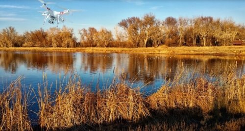
The increasing availability of drones, coupled with shrinking camera sizes, is ideal for aerial photography. It is now easier than ever to pick up the right kit, head out on location and perfect your skills. Some like to work with top of the line UAVs and equipment for the best shots possible.
Still, there are many novices with cheap quadrocopters and GoPros that can create impressive images. This means increased competition for the best locations and the best angles. It is pretty much impossible to stumble across these shots by accident. The best aerial photos come from a game plan on precisely where and when to head out. This means careful planning and some helpful tools.
Scouting For Locations Is More Difficult For Aerial Photos
Landscape photographers with a trusty DSLR camera can drive around until they find somewhere that fits the bill. Everything is on the same plain so when you find a good subject, there are no doubts that it will make for a great shot. It isn’t quite so easy with an aerial shot from a drone. You can’t exactly casually fly around for hours and see what spot you can find because:
- it wastes a lot of battery life, potentially with no reward.
- flight restrictions may make it impossible to fly around in busier areas, or anywhere close to airports.
Scouting for a location means that you really do need to plan ahead when finding the best locations for aerial photos. You can only wing it so much. So, what tricks can you use to find the very best locations for interesting images? This guide will cover the following:
- Using blogs and websites to learn more about top national and international locations
- Local forums and meet-ups to learn more about opportunities in your neighborhood
- Google Earth tools to discover locations of your own
Photographers Blogs And Websites With lists of the Best Locations for Aerial Photography
The first thing that you can do is seek out blogs on the best locations for an aerial shoot. There are lots of experienced photographers eager to show off their attempts and the awesome locations they found. There are also plenty of guides on the “10 best photography sites in [insert your location of interest here]”.
The pros and cons to this approach, but it might be a good starting point for some newcomers, but can be time-consuming. It is impossible to take bad aerial photos in some of these locations, which means plenty of helpful practice.
These tried and tested sites are popular with other drone users – either novice or professional. Using the websites means that you can be sure of a great location, and most likely a great shot, once you reach your destination.
There are lots of areas that are basically on every aerial photographer’s bucket list. Many of these might be fun to try out. The appeal of these destinations tends to depend on your own location and your budget. It is one thing to plan a road trip out of town to check out the local hills and forests. It is another entirely to start booking flights to the coast of Ireland or Australia.
There is no doubt that both of these landscapes are popular destinations. The former has some of the best scenery for those looking to improve their skills. The latter has those clear waters for impressive wildlife work.
A little closer to home, many aerial photographers head out to San Francisco. This is a sort of rite of passage for aerial photographers with all the different landscapes and themes. This city offers great city scenes at night or by day, then there are the landmarks of the Golden Gate Bridge and Alcatraz. Popular spots also allow for a little friendly competition.
The other benefit to turning to those tried and tested locations is the chance to go one better than other photographers. There may be some well-received shots from leading artists of downtown San Francisco or a feeding frenzy off the Gold Coast. But, there is always the chance that you could go one better. It is all about finding the right angle, lighting and perfect moment. Ideally, you want to capture something about this beloved location that we haven’t seen before.
That is why this familiarity is as much a con as it is a pro with aerial photos. The worst thing that can happen is that you head out to this popular location, come back with your images and your peers shrug them off as more of the same. It takes skill and luck in equal measure to come back with something fresh and new. This means that it might actually be better to avoid these popular locations and try something different.
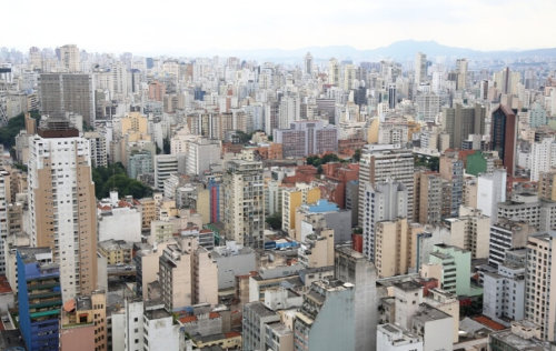
Your hometown could look as appealing as any other city with the right aerial photos.
If you truly want to say something new within your work or find a different image, seek out your own locations. There are two options here. First of all, you can look at your own city or district and think about new ways to celebrate it on film.
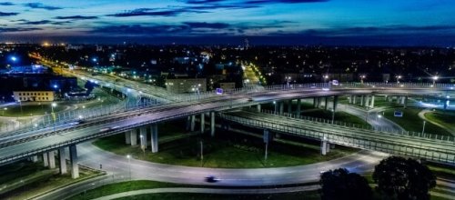
Perhaps other photographers don’t see a side of the landscape or neighborhood that you do. Maybe you know of the ideal place to try out some new techniques. Some new photographers may worry that their work won’t have the same appeal because their town is “ordinary”. There is great appeal in every day, from the patterns of lights on a highway to the decay of a rundown district. Beauty is in the eye of the beholder, so find a way to let the beauty of your town shine through. Don’t compete with San Francisco, Vegas or Manhattan on an obvious level.
A local setting is a perfect place for experimentation. Familiarity with the area means you spend more time shooting and less time prepping. This means a more efficient session and fewer worries about the drone dying late in the evening. A local setting also allows for repeat visits.
You can head to the same spot at different times of day to try out shots at different light levels. There are no long road trips and even if it doesn’t work out, there was no wasted money or effort in the trip. These initial ventures are therefore a great way to build confidence and skills before planning bigger trips. Make mistakes and learn your craft at home. Then you can head out to the Gold Coast or Swiss Mountains.
Using Local Forums and Local MeetUps For Your Area
You may have a good idea of where you want to shoot, but not how to go about it. This is where local forums and meet-ups can help. Forums are a great way to engage with local photographers and film-makers about their efforts and experiences. A friendly community of like-minded individuals can share tips and locations.
One may have discovered that a certain building lights up at sunrise, with the perfect angle to capture it from the air. Others tips can vary from equipment and exposure to the best places to park or get coffee for those early morning shoots.
Local meet-ups have a similar approach, with the same openness and conversation about the hobby. The difference here is that you get to meet these forum users in the flesh. Many will also bring their work and equipment with them. This could be a great chance to handle drones and get an idea of the kit on the market.
Printed aerial photos are a great way to showcase the artistry of shots, which then inspires other members to perfect their craft. These meetings may also provide an opportunity to build friendships with other enthusiasts. This could lead to some interesting collaborations in the future.
How To Scout And Research A Location On Your Own
The alternative is to take a road trip to a new location that no-one else seems to be shooting. The downside to this approach is that you are basically on your own. There is no-one to turn to for advice on the best angles, times of the day or places to park. The upside is that you really could come out with some great aerial photos that will make people stop and pay attention.
So how do you know if a location has potential if you have never been there before? The answer is simple. Use the same tool that you would use when researching a city or holiday destination – Google.
We turn to Google for so much when planning our lives. Why not continue this with aerial photography shoots.
Google Earth is the perfect aid for those planning a trip to a new photographic location. First of all, you can scan a region for landmarks or areas of interest. Waterfall, railroad tracks, highways weird rock formations are all ideal. These areas will all show up on a map as you scroll around. Put the map on Satellite mode and get a feel for the area.
Once you have a starting point, you can then use the tools in the Earth mode to play with the angle and topography. You don’t have to view this as a flat image. Instead, you can tilt and zoom for a reasonable 3D approximation of the area. It is a little patchy, but it is a bit like mocking up a rough draft before you create your own image. These angles and images should help you figure out the best location to set up your aerial photos.
Ask all the right questions and you can plan your trip with ease.
Google Earth is a great starting point for scouting a location, but make the most of other tools too. You can set up the directions tool in Google Maps to give the best route and approximate journey time to your chosen location. This is important when planning the shoot. Is it close enough to manage in a single day, or is this an overnight trip? You can also ask Google for the local times of sunrise and sunset for even better time management.
Smart Phone Apps Linking With Google To Save Time
A good research session is great for those that want to be completely prepared before they go. But, what happens if you take a wrong turn or get a flash of inspiration on the drive up to the shoot?
The right app can bring all the right Google tools and other features together onto your phone. That way you always have maps, directions, and images on hand.
PlanIt! For Photographers is a great example. This uses Google Maps, topographical data and information on the position of the sun, moon and Milky Way.
Really Good Photo Spots is another helpful tool for those working without a plan. You can search for spots in a local area and see great recommendations.
Remember To Follow FAA UVA Laws When Taking Aerial Photos
There is a desire to push a little further and test the boundaries when it comes to creating the best aerial photos. We want our shots to stand out from the crowd, and this could mean going higher or further than others have managed. Still, you need to work within FAA guidelines.
This means operating with the drone within your eye-line and within reasonable light levels. Then there are the other factors of flying near airports, property and over crowds. Familiarize yourself with the rules so there is no risk of a shoot getting called off or cause any injuries.
Make the most of online advice, but don’t be afraid to think outside the box either.
Many newcomers to the world of aerial photography will start out well by following the advice of others. This means heading out to those tried and tested sites and playing with settings and compositions. Yet, there will come a time when you will want to get creative and do something new with your aerial photos. Look at your hometown from another angle, capture images others have missed and search for the next top location.
Great post!