Aerial photography as a technique first emerged in France. Interestingly, however, two American citizens are responsible for the oldest surviving aerial photo taken in 1860. The photo was taken from a height of 630 meters and is a depiction of Boston.
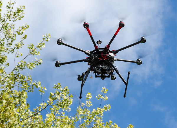
Aerial photography is best defined as the art of taking photographs of the ground from an airborne platform including both traditional and modern platforms. For example, the earliest aerial photos were taken using balloons, kites, and fixed wing aircraft.
While these are still in use, new modern platforms are in use now including helicopters and drones which are quite popular among modern photographers.
A defining feature of aerial photos is their high degrees of radial distortion; straight lines may appear as curved lines. This means that the topography is slightly altered which in turn means that any measurements taken from the aerial photo have a significant degree of inaccuracy.
It is important to note that while both aerial photographs and satellite images offer a bird’s eye view of the earth, they are not the same. First, aerial photographs cover small areas of up to a few hundred square kilometers while satellite images cover areas of up to 30,000 square kilometers.
Secondly, satellite images are taken from distances of between 600 and 900 kilometers above the ground easily dwarfing aerial photos which are taken from distances of between a few hundred meters and a thousand meters above the ground.
(Source: TheGeoScholar)
A third distinct difference between aerial and satellite imagery is the fact that bad weather is a huge constraint for aerial photography but is a non-issue for satellite imagery. However, clouds may sometimes obscure information found in the near infrared bands.
Types of Aerial Photos
There are several different types of aerial photographs. These include;
1. Oblique Aerial Photographs
This is undoubtedly the most commonly available type of aerial photo. The photographer takes the shot at an angle looking down to the ground below. There are two distinct types of oblique aerial photographs; high obliques and low obliques. Both types are further categorized as wide shot photos or close up photos.
Close ups are taken with the purpose of filling the frame with the subject of the photo. On the other hand, wide shots are taken with the purpose of showing the subject of the photo in context with the immediate physical environment of the subject. In addition to that, both types of obliques are highly distorted, and it is not possible to measure distances accurately.
Low Oblique
Low obliques are normally taken with a camera slanted at an angle of about 30 degrees from the vertical point. They cover relatively small areas and therefore do not include the horizon.
High Oblique
These are normally taken with a camera that is slanted at an angle of approximately 60 degrees from the vertical point. Such photos cover a relatively wider distance than low obliques and even include the horizon.
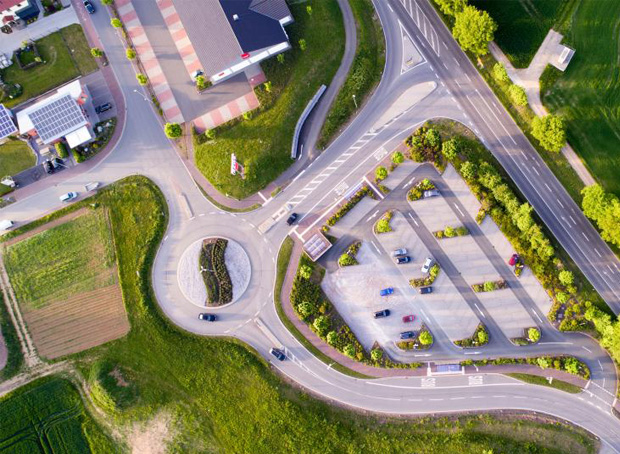
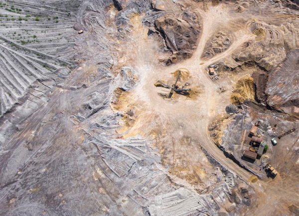
2. Vertical Aerial Photographs
Vertical aerial photos are normally taken with the camera pointed as perpendicularly to the ground and the horizon as possible. They cover relatively smaller areas and are of two types;
Near Vertical
Near vertical photos are taken with the camera almost vertically to the subject of the photograph in such a way that the camera is not perpendicular to the horizon/ground.
True Vertical
These are photos taken with the camera pointed down to the ground at a perfect 90-degree angle to the ground/horizon. However, a tolerance of 3 degrees from the 90-degree mark is allowed. This gives the resulting aerial image a map-like outlook further making it possible to scale the photograph (after rectification) and even use the measurements in the photo. True verticals are especially useful in mapping applications.
3. Orthophotos (Ortho-rectified Vertical Aerial Photographs)
Distances and measurements in true vertical aerial photographs are distorted but at the same time more accurate than in other aerial photos. This makes it possible to correct the geometric measurements of the photograph so as to make it possible to use it as a map. When a true vertical aerial photo is corrected for distortions, it is known as an orthophoto or an ortho-rectified vertical photo.
Analyzing and Identifying Objects on Aerial Photos
When researching aerial photos, people are often required to correctly/accurately identify objects. This is a delicate process that involves having a keen eye for detail. Experts in analyzing aerial photos advise focusing on several important elements;
- Scale and Size are two important and co-related elements. The size of objects is always determined in the milieu of the photograph’s scale. Scales are normally represented in ration form. Scales allow for measurement of objects in aerial photographs and may also affect one’s interpretation of objects in the image. For example, one may determine that an object is a pond and not a lake.
- Objects in aerial photos also have different hues and in different tones (varying degrees of brightness. Color and tone are in fact among the most important elements of any image as they allow for the analyst to easily discern and differentiate between many other elements under analysis.
- The third most basic element on aerial photos is the shape of objects. Shape, in this case, refers to the general boundaries/outlines of different objects on the aerial image. For example, one could determine that an object is an American football stadium simply through analyzing the shape. Some buildings such as the Pentagon also have easily discernible and unique shapes.
- In addition to that, one must also consider the texture of the objects in an aerial photo. However, it is important to note that texture, in this case, is perceived rather than “real.” To determine texture, one analyzes the frequency of color changes in an image. Items such as grass and water may appear smooth while objects such as mountains and forest canopies may look rough.
- Pattern is also an important element to consider when analyzing aerial photos. For example, a cluster of unmanaged trees may appear as a random pattern while rows of corn or even orchards may take on more distinct and organized patterns.
- Objects that rise above the landscape cast different shadows in aerial images. Shadows may either aid or constrain image analysis. For example, the length of the shadow is important in calculating the height of objects. On the other hand, a shadow cast on other objects may make it harder to identify those objects within the shadow.
- The topographic or geographic location in which the aerial photo is centered on is also essential. This is especially true when the analysis is meant to identify different types of vegetation or other natural features on images.
In Central Florida for example, sinkholes are common because the rock below the surface is comprised largely of limestone. Aerial photos of the region may feature objects appearing as large circular depressions.
- Equally as important is the manner in which the object in question relates/associates with other objects around it. For example, one would not expect to find a military weapon testing plant in the middle of a residential area. Similarly, airports will have long strips of tarmac, several buildings, and huge parking lots.
Uses/Applications of Aerial Photographs
Aerial photographs are used for some professional applications. Some of these include;
1. Disaster Risk Reduction, Prevention, and Response
Aerial photographs are widely used in the process of reducing and preventing the risk of disasters. Aerial images allow for the analysis of topographic and geographical features so as to determine the potential of risk and when necessary, enhance the planning and implementation of necessary changes needed to avert the risk.
Risks may include natural disasters such as overflowing rivers, landslides, heavy rainfall and even wildfires among others. For example comparing different images may help analysts determine how bad deforestation in a certain area is an aid in the process of finding suitable solutions for the situation.
In addition to that, knowing the topographic and geographic elements of an area can help determine whether the area is suitable for a camp or a housing project in anticipation of a potential disaster such as a hurricane.
Aerial photos can also come in handy when responding to natural disasters. For example, an after earthquake aerial photograph of an area may help determine the extent of the rapid changes resulting from the earthquake particularly when compared with a pre-earthquake aerial photo. Furthermore, response teams can use aerial photos to determine populations that are most at risk from the effects of the earthquake and subsequently facilitate timely intervention.
2. Protection of the Natural Environment
Comparing aerial photos taken at different time periods may help determine how an area or element of the natural environment has changed over time. Any observations made are then incorporated into the already existing plans and regulations based on the required solution. For example, a comparison of two different aerial photos may determine that vegetation in a certain area has increased or decreased thus allowing for more informed decision making. Aerial photos may also show the effects of global warming on a glacier.
3. History, Earth Sciences, and Cartography
Historians compare aerial photos from different periods of time to determine changes in an area over time. Some also use aerial photos when researching on subjects such as war. Aerial photos are even more common in earth sciences such as ecology, geology, archaeology, and geography among others. For example, archaeologists have often used aerial images to locate “lost” monuments or track features such as soil marks and crop marks.
Cartography is the science of making maps, and it is a process in which aerial photos are an important and useful element. Aerial photos help to provide a clear-cut portrayal of the actual features (physical and cultural) of an area at any given time.
4. Urban Planning
Information from aerial photos is commonly used for various urban planning and development applications. For example, aerial photos are often used in the process of evaluating things such as the cost and most appropriate routes/locations of constructing infrastructure projects such as transport channels and critical utilities such as power plants.
5. Military
The military is one of the foremost users of aerial photos. They are commonly used in reconnaissance. Aerial photos may provide vital information such as the topographic and geographic outline of an area and even help in identifying military installments in a particular field.
6. Other Applications
These days, aerial photos are used in a wide range of activities including movie and film production, advertisement, tourism, journalism and even agriculture among other applications.
Sources of Aerial Photographs
There is a wide range of sources for different collections of aerial photos. Two distinct categories of sources are identified: federal and Nonfederal sources.
1. Federal Sources
The government is by far the biggest single source of aerial photographs. Some of the most important of these include:
. United States Geological Survey (USGS)
Founded in 1879, this is one of the biggest sources of aerial photographs particularly those from 1939 to present time images. Images are available in print, positive, negative and even digital formats. Films are available in black & white, CIR and color formats.
. United States Department of Agriculture (USDA)
Aerial photos belonging to the USDA are stored in the Aerial Photography Field Office in Salt Lake City, Utah. Aerial photos from the 1940s to present times are available. Films are available in two formats: black & white and CIR. Photographs are available only in print, negative and positive formats.
. National Archives and Records Administration (NARA)
NARAs collection of aerial photos includes more than 9 million photographs from the civilian and military branches of the U.S government. However, these photos are only those taken between 1935 and the 1960s. What’s more, they are only available in black and white print formats.
. Library of Congress
It is considered one of the world’s largest libraries and is a great resource for aerial photographs too. The aerial photos date from as far back as the 1900s and also include aerial photos from present times.
. National Ocean Service
This is a branch of the U.S Department of Commerce National Oceanic and Atmospheric Administration. Having conducted aerial surveys of the U.S coastline and airports since as far back as the late 1930s, NOS has accumulated more than 500,000 photographic negatives from 1945 until present times.
. Other State Agencies
Many other State Agencies have collections of aerial photos in the United States. For example, the Iowa Geographic Map Server has aerial photos from the 1930s while the Iowa Aerial Photo Indices has a collection of photographs from the 1930s to the 1980s. On the other hand, the North Central Texas Council of Governments is an excellent source of aerial photos of Dallas-Fort Worth Metro particularly those from 1999 to 2011.
2. Non-Federal Sources
There are also Non-federal sources of aerial photos including;
- The NGA-Earth website which also includes aerial photos of other parts of the world.
- Bing Birdseye and Orthoimagery website which includes aerial images from specific states.
- Google Maps Orthoimagery website which includes photographs of other parts of the world as well.
- NASA Worldwind website includes photographs of other parts of the world.
I appreciate the subject